How to Climb Volcan De Acatenango in Guatemala
Difficulty: Very Hard
Elevation Gain: 5,000+ feet
Elevation Trail-Head: ~7,800 feet
Max Elevation: 13,045 feet
Climbing Volcan De Acatenango without a guide
We landed at Guatemala City airport, got our rental car and started driving West in the direction of Acatenango. Right off the bat we discovered the traffic here was brutal. In the city it was rush-hour 24/7. The short distances we needed to drive took a very, very long time and roads in and around little villages quickly turned into cobblestone and dirt. Even on the northern highway route to Lake Atitlan, the highway was full of very large potholes. I am surprised we didn't blow a tire.
We got an airbnb the first night we were in Guatemala in the city of Antigua, which was somewhat near where we needed to be to start the hike in the morning. Sometimes we car-camp on our trips but this time we wanted to be well-rested for the hike because we knew it was going to be hard, especially because our packs were insanely heavy, about 50 pounds each. Heavy packs is an annoyance on flat trails but can become a huge burden when hiking uphill and at higher altitudes where there is less oxygen to feed your muscles. We ended up sleeping in this really old, tall, and creepy house place. It had old-timey lock and keys, old mirrors, weird secret windows, and giant dark-wooden wardrobe cabinets. We thought for sure it was haunted... Anyway, we were here to get a good night sleep and that definitely didn't happen... Austin's bed was small and hard as a rock, Michael kept waking-up all night, and I puked about 8 times in the middle of the night (presumably because I am not used to higher altitudes, in combination with possibly eating something bad in the village for supper...
We woke up around 6 AM (I was already awake 🙁 ) and we drove West toward the trail-head for the Acatenango hike. I takes 1 hour to drive from Antigua to the trail head, and is only 15 miles... Crazy roads and slow traffic...
The entire time we were in the car we were chugging water bottles and eating food. Our philosophy is the more food and water you consume beforehand, the less you need to bring along on the trail and therefore less weight for us to carry. (There's no water anywhere on the mountain). We got to the trail head and parked our car on the street, not really caring if anyone broke-in, considering we had all our important stuff with us in our backpacks. (Nobody broke into our car.) We chatted and waved to a family and some kids near where we parked our car.. though our Spanish is pretty terrible so our conversations weren't very coherent and mostly consisted of smiling and waving.
We all got on our boots, chugged our final waters, and grimaced as we put-on our heavy packs and looked up in the sky towards the mountain. We all agreed this was going to be very, very, very hard...
Because we weren't going with a guide or company, we had to be completely self-sufficient. We carried our own tent, sleeping bag, camping mats, food, water, camera, tripod, drone, batteries, jackets, pants, gloves and the bare minimum gear we needed to survive a night at the cold summit. The bottom of the hike is very hot and sweaty, though the wind blows you dry and it can get a little chilly if you stop walking for a while. I wore a light long-sleeve shirt to block the sun from my arms, shorts, and a hat. (We all got sunburned during the hike up and down.)
Hiking up with heavy packs was very difficult as we imagined, and got harder and harder the higher we climbed. I always knew what altitude we were at from the altimeter on my watch. The higher we got, the slower we had to hike.
The beginning of the hike is a little confusing, there are parts where we got a little lost and had to walk through some dirt fields, eventually we located the trail again and continued our way up the mountain.
About two miles up the mountain we ran into a little bit of trouble. There is a small rest-point, consisting of a couple shacks/structures. Here there were a couple gentlemen who spoke some English but mostly Spanish. At first we didn't know what they were talking about or trying to tell us.. then eventually we understood that they were telling us we were not allowed to continue on the trial without a guide because it was too dangerous or we would get lost or something... We were unsure if this was a scam, or a real requirement. Either way were weren't going to do it with a guide and we didn't have any money with us even if we wanted to pay for one.
We ended up going back down the trail a ways, and then started spelunking headfirst into the Guatemalan jungle. We needed to cut through the jungle for about 2,000 feet to avoid those gentlemen.. This was extremely hard because the jungle was super thick and straight uphill. Vines would constantly catch my backpack and pull me backward. Luckily no venomous creatures nibbled on us and after some time, we made it higher up the mountain, through the jungle, and past the guards.
Continuing on the hike, the sun was still blazing but the temperature was dropping a bit due to the higher altitude. We sipped our water sparingly and sometimes rested by laying in the middle of the trail in the sun like a dog in the driveway.
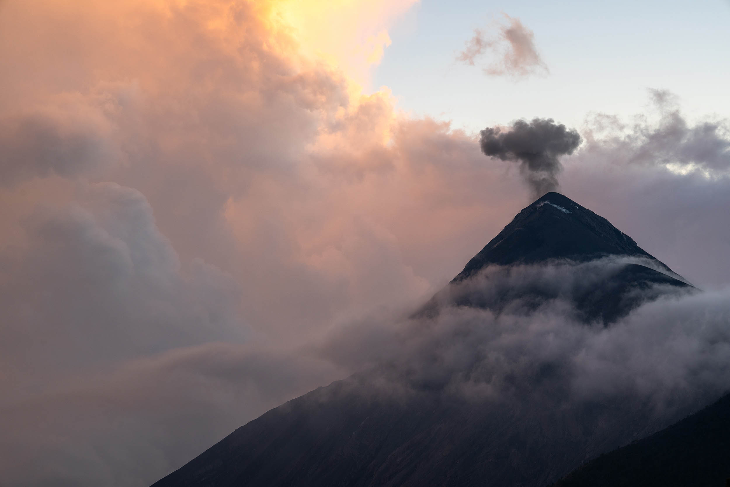
As we got higher and higher we were glad we started the hike early in the day (around 8 or 9 AM) to give us plenty of time to not worry about the sun setting. We could still not see Volcan de Fuego, as Volcan de Acatenango blocks its view for almost the entire journey.
Near the top we started skirting the mountain on the East as we headed toward the Base Camp/Base Camp Area.
Nearing our destination, we started to hear sounds like Thor raining down hammer-strikes from the heavens... Peaking through the trees we saw our fist glimpses of Volcan de Fuego.
Sticking out through the clouds, we could see the black mountain smoking in the distance.
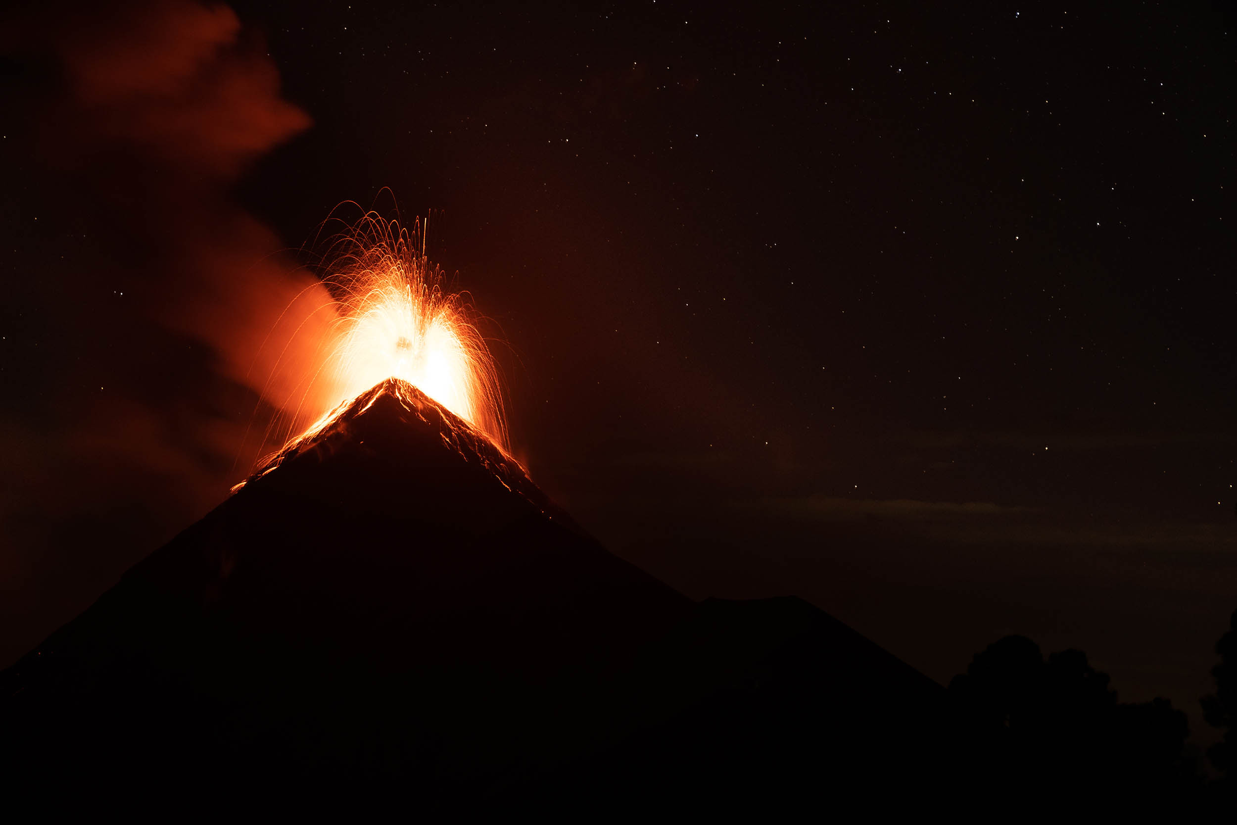
Boom!! Just like that we saw the peak erupt. With a sound wave hitting my chest I watched the pinnacle create a mushroom cloud like a small atom bomb. The cloud rained-down boulders the size of trucks and I could hear these trucks ominously crashing down the mountain for the following 30 seconds. A truly unbelievable sight like nothing anywhere else on Earth. (The locals told us that Volcan de Fuego was extra active these days..)
We continued hiking and eventually got to base camp. Here there were various camping spots to choose from. We chose one away from the others where we could relax and do our own thing, with a perfect, unobstructed view of De Fuego.
The mountain continued to erupt as we set up our tent. Constantly blowing its lid every ten or fifteen minutes. Every so often with each new one being more impressive than the last.
We had a two-person tent for 3 grown men! My brother is 6'3" and me and Austin are both around 6 feet. We didn't really fit to say the least...
Our sardine-can tent ended up being fine because it was absolutely freezing at night. Like I was saying earlier, because we had to carry everything up the mountain ourselves and because our packs were already way too heavy, we had to make sacrifices in what we decided to bring. We decided to bring just one sleeping bag, which we ended up all having to share as a blanket inside the tent. We had two small sleeping mats to insulate us from the ground and other than that, had to rely on our jackets and pants to keep us warm enough during the night. I have a thermometer on my watch and it was at 36 degrees F during the night. We were very uncomfortable and didn't really sleep during the night...
Before we got into our sardine-can, we stayed up during the night, sitting around a fire that we built while eating our supper like cowboys. Volcan De Fuego was our TV and continued to erupt every 10-15 minutes throughout the entire night.
Watching the volcano erupt at night was even more fantastic than watching it in the daytime. In the daylight, the sun overpowers the lava, but at night when there is no other light but from the stars, the lava explodes out of the mountain and flows down the sides for thousands of feet, glowing an extremely bright red.
We all agreed this was one of the coolest things we have ever seen on planet Earth in our entire lives.
It was literally like seeing a volcano in a cartoon dinosaur movie, it didn't even seem real.
When we got up in the morning, we expected to see some snow or sleet on the tent, as we heard it falling against the ceiling during the night.
I brushed my hand over the top of the tent, it was black ash and little tiny rocks from de Fuego.
In the morning we watched the sun rise up from below the clouds and return warmth to our campsite.
We ate some more food and sipped our last waters as we watched de Fuego erupt for the last time then we packed up our tent and headed out.
The hike back down was so much incredibly easier as we did not have to deal with going uphill and the air got thicker and thicker as we descended.
We got back to our car, knees and legs in pain, and fully exhausted but we were all in agreement that what we just did was truly great.
See these pictures and our latest badassery on my Instagram @1Lifeonearth


FAQ
How cold is it on top of Volcan De Acatenango?
It was 36 degrees F on top Acatenango in January at night. In the day it's much more tolerable around 50's or low 60's F.
Where is the trailhead for the Volcan De Acatenango hike?
If you enter these grid coordinates into Google, it will show you where we started the trail: 14°32'07.6"N 90°53'10.8"W
There is also another trailhead 1,200 feet East down the road, both these trails weave into each other after a few thousand feet.
How hard is the hike up Acatenango?
It is very hard if you carry your own pack and don't have a guide/porters. If you have guides and porters to carry your stuff or provide you with tents/food/water it will be much easier.
How do you hike to Volcan de Fuego?
You climb this exact same trail, then at the basecamp of Acatenango, you take another path that takes you to Volcan De Fuego.
Do you need a guide to hike up Acatenango volcano?
Yes, apparently you are required to have a guide if you wanna do the hike. We did not have a guide so you can do it without one, you jut have to be creative. Another couple we saw said they paid a guide 20 bucks to say they were with his group just so they could get past the guard, then they continued on their own.
Can you have campfires on Acatenango?
Yeah you can.
Is there water available anywhere on Acatenango Volcano hike?
No there's none, so make sure to bring enough.
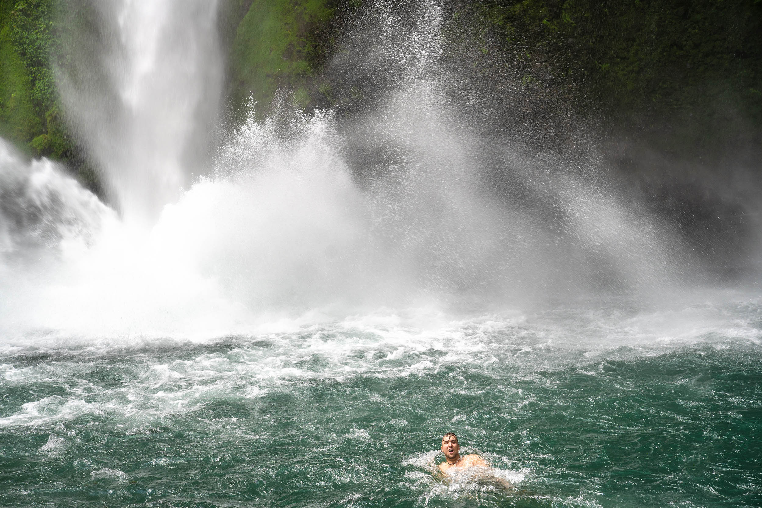
What's the best place to go cliff jumping / cliff diving in Guatemala?
Definitely go to Lake Atitlan. It is absolutely beautiful and has a really good spot for cliff jumping. The place we went is called Cerro Tzankujil (Nature Reserve) and it was really fun. There's cliffs that are about 30-40 feet tall, and then smaller ones as well. This is in a little village called San Marcos La Laguna. This was the coolest place ever and we had a really awesome experience staying here for a day and a half. We even played basketball with the local kids in an outdoor basketball arena thing. This village and Lake Atitlan was very beautiful and I would recommend it to everyone. It had some janky roads though so make sure you rental car has a spare tire...
My AirBNB code to get $30 off your booking click HERE
Some of my Supplies that I took on our hike:
My Hiking Boots: https://amzn.to/2OVRa6T
My Altitude Watch: https://amzn.to/2URCN7j
My Hiking Pack: https://amzn.to/2HoisOW
My Hiking Shirt: https://amzn.to/2UWZeI3
My Camera: https://amzn.to/2V1cVWN